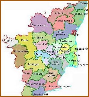
To give you an idea of Tamil Nadu and the exact location of Tiruvannamalai District here follows a short profile of the State and a map of its current delineation into Districts:
Tamil Nadu, the southern most State of India, has a very ancient history going back some 6,000 years. The State represents Dravidian culture, which preceded Aryan culture. The four great kingdoms of the Cholas, Cheras, Pandyas and Pallavas that ruled this area until the 10th Century A.D., left behind a rich legacy in art, architecture, music and literature and created lasting political, economic and agrarian systems. An intervening period of unstable Muslim rule that allowed the State to slowly disintegrate into several petty kingdoms coincided with the arrival of the East India Company in Madras in 1639. Soon most of south India came under the hegemony of the British.

In 1947 when India attained independence, the Madras Presidency comprised of present day Tamil Nadu, Andhra Pradesh, Karnataka and Kerala. The agitation for a separate State for the Telegu speaking region forced the central government to bifurcate the Madras Presidency and create Andhra Pradesh. Under the State Reorganisation Act of 1956, Madras was divided further and the States of Kerala and Mysore (Karnataka) came into being. In 1967 Madras State was renamed Tamil Nadu; today it is the fourth largest State of the country. It has a population of approximately 70 million, about 6% of the total Indian population, and 30 Administrative Districts.
2 comments:
I had no idea that the state of Tamil Nadu was only named as late as 1967! So that is why even some people in their 50's and 60's still refer to it as "Madras state"
Yes. India's borders seem to be constantly redefined. Such a big country filled with so much history and traditions.
Post a Comment